To validate the model footprints, observational data were extracted from the Met Office Integrated Data Archive System (MIDAS). For each of the storms in the catalogue, all stations within the model domain which recorded maximum gusts during the 72 hour period used to create the model storm footprints were selected.
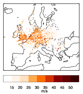
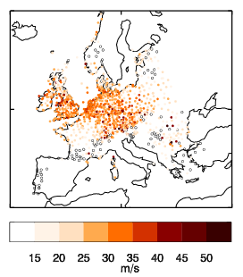
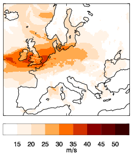
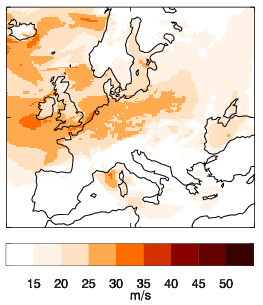
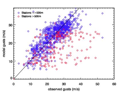
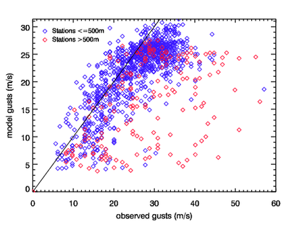
On the storm profile pages we show the observational footprints for each storm, which show the maximum gust recorded at each station where data was available over the same 72 hour period as the model footprint. We also show scatter plots of model maximum gusts against observed maximum gusts for all of the stations in the observational footprint for each storm. The model maximum gusts for each specific station location were estimated using bilinear interpolation. Some examples are shown below
| Jeanette | Kyrill |
|---|---|
|
|
|
|
|
|
|
Top row: observational footprints for the storms Jeanette (October 2002). and Kyrill (January 2007). Middle row: corresponding model footprints for the same storms. Bottom row: plot of model gust versus observational gust for each of the stations plotted in the observational footprint. Gusts from stations with altitudes greater than 500m are plotted in red, and those with altitude ≤500m are plotted in blue. The black line shows y=x. |
|
In general the model and observations agree on the location of the storm (although it is difficult to confirm the exact location given the irregular locations of the observations). Also the scatter plots show that the gusts are scattered about the y=x line, showing that in general the model gusts are in agreement with the observations.
However, two problems with the model are apparent:
Problem 1 is caused by the use of an effective roughness parametrisation, which is needed to estimate the effect of sub-grid scale orography on the synoptic scale flow. The use of this parametrisation does indeed result in more realistic synoptic flow, yet it causes unrealistically slow wind (and hence gust) speeds at 10m (Howard & Clark 2007).
Problem 2 is probably caused by the model not fully capturing the steep pressure gradients.
More details of the model performance and reasons for bias are given in the forthcoming paper (link to come). To correct for these issues the footprints have been re-calibrated (see Recalibration section).
Licensing: The data provided on this site can be used for research and commercial purposes under the Creative Commons CC BY 4.0 International Licence: http://creativecommons.org/licenses/by/4.0/deed.en_GB. The following citation should be used for the XWS Datasets: (c) Copyright Met Office, University of Reading and University of Exeter. Licensed under Creative Commons CC BY 4.0 International Licence: http://creativecommons.org/licenses/by/4.0/deed.en_GB.
Disclaimer: The organisations involved give no warranty as to the quality or accuracy of the information on this website or its suitability for any use. Your use of information provided by this website is at your own risk.